Everybody has heard of the Grand Trunk Road, and most of what everybody has heard is wrong.
This is partly Kipling's fault and mostly not. The road has been written about for two thousand years by people with reasons to simplify it: Mauryan administrators, Mughal chroniclers, British surveyors, and latterly tourism copywriters who found that one emperor and one sentence made a cleaner story than four dynasties and a lot of uncertainty. The result is a road that almost nobody can describe accurately and almost everybody feels they know.
So this piece does two things. It gives the history as it is actually documented, including where the documentation runs out. And it tells you what is left to see, with monument numbers, because a road you cannot visit is a lecture rather than a journey.
The road was found in 2016
Start here, because it is the fact that reframes everything else.
In December 2016 the Archaeological Survey of India announced the discovery of a stone causeway across the Sone in Bihar: four kilometres long, twenty feet wide, built of dressed sandstone slabs around ten feet across, running between Kanbaheli in Aurangabad district and Bansa in Rohtas district. It had been exposed because a monsoon discharge from the Indrapuri barrage stripped away the sand and silt that had covered it.
The then Director General of the ASI, Rakesh Tewari, put it in terms that are worth reading twice: this was the first time they had actually discovered an original part of the ancient or medieval Grand Trunk Road.
The previous documentation of that causeway was Sir William Hunter's A Statistical Account of Bengal, in 1876. It had been out of the record for a hundred and forty years.
Hold that against the confidence with which the road is usually described. The most written-about road in South Asia, and the first verified stretch of its original surface turned up by accident, under a river, within the last decade. It also sits about a kilometre west of the modern alignment — which tells you something useful about how much of the historic road the present highway is actually following.
Who built it, honestly
The road's antecedent is the Uttarapatha, the northern route, which predates the Mauryas. Its first imperial construction is credited to Chandragupta Maurya. Ashoka, his grandson, did something more interesting than build it: he provisioned it.
Major Pillar Edict VII, from Ashoka's twenty-seventh regnal year, records banyan trees planted to give shade to cattle and men, mango groves, wells dug, rest-houses built, and watering places made for animals and men. It is the earliest such provision documented on the Indian royal road itself. We will not go further than that — we have seen the claim that it is the oldest record of road amenities anywhere, and we could not verify any priority claim of that kind.
One caution on the detail everyone quotes. The spacing of the wells is translated differently by different scholars: Hultzsch and Dhammika read eight kos, V. A. Smith reads every half-kos. If you want to state an interval, state that the translations differ.
Then Sher Shah Suri, who ruled from 17 May 1540 to 22 May 1545 — five years and five days. He rebuilt and modernised the road, repaired what the sources describe as Chandragupta's royal road, realigned its eastern arm towards Sonargaon and Rohtas, and added caravanserais, mosques, wells and trees along both sides. That is a formidable record for five years. It is not the same as building the road, and the difference is not pedantry: the version in which an Afghan ruler conjures a two-thousand-kilometre highway in half a decade erases both the Mauryan road under it and the Mughal century of sarais and bridges on top of it.
The Mughals renamed rather than rebuilt — Badshahi Sadak, the royal road — and the British metalled and renamed it again. The name Grand Trunk Road is theirs.
The road has never had one eastern end
This is the second thing that surprises people who know the road well.
UNESCO's own Tentative List entry sets out four phases with four different terminal points. The Mauryan Uttarapatha ran from Balkh to Tamluk. The Sur-era Sadak-e-Azam ran Kabul to Sonargaon. The Mughal Badshahi Sadak, Kabul to Sonargaon. The British Grand Trunk Road, Kabul to Chittagong.
Kolkata is the historic terminus of nothing. It is where the colonial administration put the eastern end for its own reasons, and it stuck because that is the version the railways and then the road atlases inherited. The full modern road, Teknaf on the Bangladesh–Myanmar border to Kabul, runs about 3,655 kilometres.
Kos minars, and why they are not milestones
The brick pillars along the road are its most recognisable survival and its most misunderstood.
A kos minar marks a kos. The problem is that a kos was never a fixed distance. The Arthashastra gives roughly 3,075 metres. Akbar standardised it at 5,000 guz, which the British rendered at thirty-three inches to the guz, producing about 4,191 metres. Other conversions give 1.8 kilometres, or two English miles. That is a spread of more than 130 per cent, which means the pillars cannot be used to measure the old road and are not evenly spaced in any modern unit.
The attribution needs care too. Akbar did order a pillar at every kos in 1575 — but, according to the Akbarnama, on the road from Agra to Ajmer, the pilgrimage route, not the Grand Trunk Road. The surviving minars on the Agra–Lahore trunk are generally Jahangir-era. Sher Shah is credited with earlier brick pillars plastered with lime, so the fashionable correction — that Sher Shah had nothing to do with them — overshoots in the other direction.
About 110 survive. Haryana has 49. Punjab has a run through Jalandhar, Ludhiana and Tarn Taran. The densest surviving sequence anywhere is the Delhi–Agra line, numbered outward from Delhi, with minars 10 to 27 in Faridabad and Palwal districts.
Forty-four of them are in India's UNESCO submission. Around sixty are on the ASI protected list. One hundred and ten survive. Those figures do not reconcile, and anyone citing a number should say whose number it is.
The monument that went missing
In March 2024 the Government of India issued a notification under section 35 of the Ancient Monuments and Archaeological Sites and Remains Act, 1958, declaring eighteen protected monuments to have ceased to be of national importance. The protected list went from 3,693 to 3,675.
The reason, in several of the eighteen cases, was that nobody could find them.
Two kos minars were among them. The National Monuments Authority's own list records Kos Minar No. 13, at Mujesar in Faridabad district, Haryana, under the Chandigarh Circle, with the word 'Missing' beside it. A kos minar at Karnal went the same way. Mujesar is on the Delhi–Agra leg of the Grand Trunk Road, which is what makes this a story about this road rather than a general one about Indian heritage administration.
The scale behind the notification came out in Parliament. The Ministry of Culture told the Parliamentary Standing Committee on Transport, Tourism and Culture in December 2023 that fifty protected monuments were untraceable. The trajectory is longer than that: ninety-two declared missing in 2013, forty-two subsequently traced, twenty-four unlocated by 2015, fifty by 2023. In July 2025 the Culture Minister confirmed the eighteen delistings in the Lok Sabha.
Put the two facts from this piece side by side. In 2016 the ASI found four kilometres of the original road under a river in Bihar. In 2024 it struck a kos minar off the protected list because it could not be found in Faridabad. The same road, the same decade, the same agency.
What is actually left to see — Delhi to Amritsar
The Delhi–Lahore arm has the better survivals, and almost none of them are signposted from the highway. ASI numbers below are from the official Monument of National Importance lists for Punjab and Haryana; where we are relying on journalism for condition rather than on an ASI assessment, we say so.
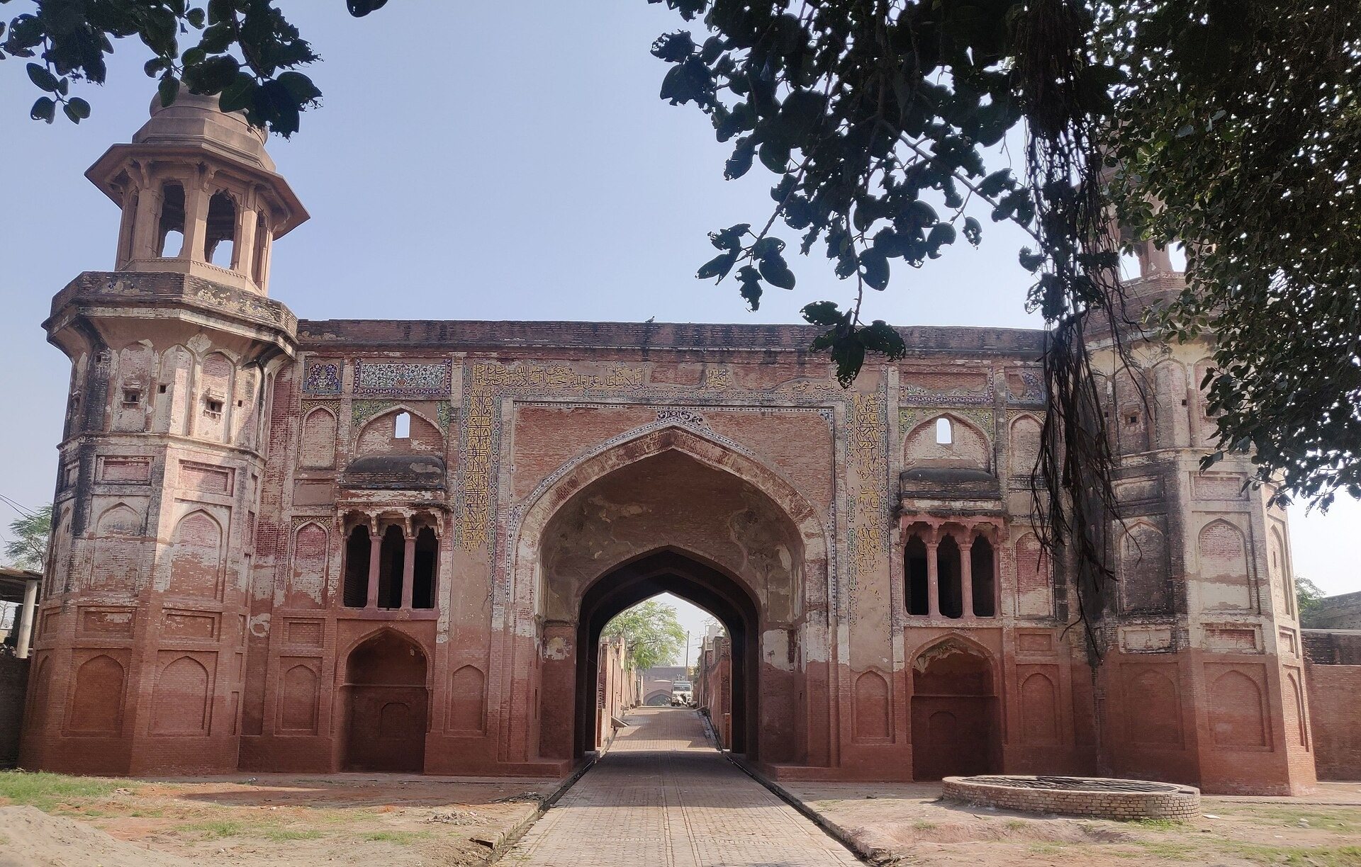
Serai Nurmahal, Jalandhar district, ASI N-PB-17, is the single best thing on this road and the most extraordinary. Built in 1618, ordered by Nur Jahan and executed under Zakariya Khan. Its gateway breaks the Mughal convention against figural sculpture comprehensively: carved angels, nymphs, lions, elephants, birds, peacocks, men on horseback, an elephant fight, and four horsemen playing chaugan — polo — flanking the inscription. Commissioned by a woman, in defiance of the rule, in 1618. The building is now bisected by a wall, with a primary school in one half and a police station in the other.
Dakhni Sarai, at Mallian Kalan in Jalandhar district, ASI N-PB-12, is largely intact: 180 by 172 metres, thirty rooms to a side, both gateways standing, a three-domed mosque with two minarets, the ruins of a hammam. Its builder is genuinely unsettled — Wazir Khan in the 1630s or Ali Mardan Khan in 1640, and the sources do not agree. A leper colony for three hundred people was established on the site in 1870.
Sarai Amanat Khan, Tarn Taran Sahib district: the gateway is ASI N-PB-1, and the distinction matters, because the ASI protects the gateway rather than the sarai. It was built in 1640 or 1641 — 1050 Hijri by the foundation inscription, which is written in the first person — by Amanat Khan, the nobleman who did the calligraphy on the Taj Mahal. About five hundred people live inside it. Before Partition the sarai was shared by Hindu and Muslim families; in 1947 the Muslim families left and refugees from across the border settled there, and their descendants are there now, eighty years on. The American Institute of Indian Studies, which recorded the oral history, calls it a living monument. Some descriptions call it illegally encroached. The first framing is both better sourced and more accurate.
Fatehabad, Tarn Taran Sahib: ASI N-PB-2, the gateway of the old Sarai Akbar or Jahangir on the Delhi–Lahore road, with glazed tilework in rich blues, yellows and greens. The keys are held by a neighbouring farmer, which is to say it is accessible if you ask and locked if you do not.
Also on this arm: the Ustad–Shagird tombs at Nakodar, ASI N-PB-16, a court musician and his pupil, 1612 to 1657, on well-kept grounds; Shambhu Sarai near Ambala, the best-preserved sarai on the Haryana stretch with around 140 rooms, a well, a mosque and a baradari; the twin gateways of Gharaunda sarai in Karnal district, ASI N-HR-36, built in 1632 under Shah Jahan and now swallowed by the town; Sheikh Chilli's tomb complex at Thanesar, ASI N-HR-58, with its own sarai, mosque and madrasa; Choron-ki-Baoli at Maham in Rohtak, ASI N-HR-78; the Mughal bridge over the Buriya Nala in Karnal district, ASI N-HR-16; and Doraha Sarai in Ludhiana district, Jahangir-built, with two painted gateways and around fifty to seventy rooms — dilapidated, and not visible from the road.
That last detail recurs. Doraha, Dakhni and Nurmahal are all described as invisible from the modern carriageway, which is itself the evidence that the highway has drifted off the Mughal line.
Delhi eastward, and Sasaram
The eastern leg is less well served by accessible documentation — the ASI's own site is not reliably reachable, and we have not verified the Uttar Pradesh and Bihar monument numbers ourselves, so we are not printing them.
What we can give you is the anchor. The tomb of Sher Shah Suri at Sasaram is an ASI Monument of National Importance and a named component of India's UNESCO submission, bundled with the minor rock edicts, Shergarh Fort and the tomb of Alawal Khan. It is not a World Heritage Site, whatever the local signage says.
It was commissioned around 1542 and completed on 16 August 1545, about three months after Sher Shah's death. It stands 122 feet high, with an external dome diameter of eighty feet, a three-storied octagon in red sandstone that derives from the Sayyid and Lodi octagonal tombs of Delhi — and it was originally painted in bright colours and set with glazed tiles, which is almost impossible to picture now.
It sits in an artificial rectangular lake, locally called the pani roza, originally about 1,200 feet east to west by 900 north to south. The causeway you walk across to reach it is not original: the ASI built it in 1914 and 1915. In the same complex is the tomb of Hasan Khan Suri, Sher Shah's father, commissioned by Sher Shah, finished earlier, and the prototype for the larger building.
Further west on this leg, Rohtasgarh Fort above Dehri-on-Sone is a vast ruin and worth local guidance rather than a map. The medieval causeway found in 2016 crosses the Sone near here.
India's UNESCO submission names the eastern components it would like considered: Mathura, Agra, Sikandara, Kaushambi, Varanasi and Ayodhya in Uttar Pradesh; Sasaram, Patna, Vaishali, Nalanda, Rajgir and Bodh Gaya in Bihar; Topchanchi in Jharkhand; and Chandraketugarh, Tamluk, Burdwan, Nutanhat and Kulutia in West Bengal.
What the road is called now
The 2010 renumbering of India's national highways scrambled the old names, and the result confuses even people who drive the road regularly.
Kolkata to Agra is now NH 19, the 1,269-kilometre Agra–Dankuni road through Kanpur, Allahabad, Varanasi, Mughalsarai, Sasaram, Aurangabad, Asansol and Durgapur. It was NH 2, the Delhi–Kolkata Road.
Agra through Delhi to Jalandhar is now NH 44 — which was the Delhi–Agra part of NH 2 plus the old NH 1 to Punjab. Jalandhar to Amritsar and on to Attari is NH 3, formerly NH 1. Across the border the road is Pakistan's N-5 to Peshawar and the Khyber, and Afghanistan's AH1 to Kabul and Ghazni.
One correction worth making, since the claim is everywhere: the Grand Trunk Road is not NH 44. NH 44 is India's longest national highway, 4,113 kilometres from Srinagar to Kanyakumari, assembled out of the old NH 1A, NH 1, part of NH 2, old NH 3, NH 75, NH 26 and NH 7. The historic road is a fragment of it.
Kipling, and the oldest text about the road
Kim, published in 1901, is why the Grand Trunk Road has a literary reputation at all, and Kipling's description of it as a river of life is the single most quoted sentence about any road in India.
He lived on it, more or less. He arrived in Lahore in October 1882, aged sixteen, to work on the Civil and Military Gazette, stayed until November 1887, then moved to Allahabad as assistant editor of The Pioneer for 1888 and 1889, leaving India in March 1889. Both cities sit on the historic road. That is about six and a half years as an adult in India, not the seven that often gets quoted.
What we could not find is any documented journey by Kipling along the Grand Trunk Road. His documented reporting travel was in western Rajputana, collected in From Sea to Sea, and annual visits to Simla between 1885 and 1888. The Kipling Society's own scholarly notes to the relevant chapter of Kim discuss the road's history and say nothing about Kipling having travelled it. We put that as no documented journey has been identified rather than he never went, because absence of evidence is not evidence.
Those same Kipling Society notes describe the road as built and metalled by the British Raj on foundations laid out in the sixteenth century by Sher Shah Suri — which is the folklore, in a specialist publication, with footnotes. The error is that durable.
There is a nice coda about the oldest text connected to the road: it is no longer on the road. Pillar Edict VII survives only on the Delhi-Topra pillar, which Ashoka raised at Topra Kalan in what is now Yamunanagar district, Haryana. Firoz Shah Tughlaq moved it to Delhi in the 1350s, on a forty-two-wheeled cart that required eight thousand four hundred men — two hundred to a wheel — then by barge down the Yamuna, packed in silk-cotton from the simal tree, then reeds, then raw hide. It stands at Feroz Shah Kotla.
Attari–Wagah, carefully
The flag-lowering ceremony at the Attari–Wagah border is the road's symbolic terminus for most visitors, and its status changed in 2025.
The Border Security Force suspended public entry at all three retreat locations — Attari, Hussainiwala and Sadqi — on 8 May 2025, citing public safety, following the Pahalgam attack and Operation Sindoor. The ceremony resumed on 20 May for media and from 21 May for the public.
Three elements of it did not come back: the handshake between the BSF and the Pakistan Rangers, the opening of the gates during the flag-lowering, and the exchange of sweets. No authority has described those changes as permanent, and we are not going to describe them that way either. They were discontinued in May 2025 and remain discontinued as of the most recent reporting we could verify. Anyone planning around the ceremony should check its status close to the date.
How we would actually travel it
Not in one run. The road as a continuous drive is a punishing idea and a bad one: the modern highway is a freight corridor, and the surviving heritage is set back from it, locked, unsignposted or occupied.
The Delhi to Amritsar arm is the one that works as a journey, over three or four days, because the sarais and minars come at a workable rhythm and the Punjab survivals are the best in the country. Nurmahal, Dakhni Sarai, Nakodar, Fatehabad and Sarai Amanat Khan in sequence is a genuinely strong itinerary, and one that essentially no visitor to Amritsar does. Several of these need a key, a phone call or an introduction, which is the actual work of the trip.
Sasaram is a different proposition and belongs with Bihar — Bodh Gaya, Nalanda, Patna — rather than with Punjab. The tomb in its lake at first light is one of the great sights of eastern India and it receives a small fraction of the visitors it should.
Between the two there is a documentation project worth knowing about, because it is the reason this piece could be written with monument-level detail at all. Between 2023 and 2025 the American Institute of Indian Studies, funded by the United States Ambassadors Fund for Cultural Preservation, documented around 180 Mughal monuments along the road from Agra to Amritsar, across Uttar Pradesh, Delhi, Haryana and Punjab, including more than a hundred measured drawings of twenty-three monuments and to-scale three-dimensional models of five. It was documentation rather than a survey, and the project's own interim target was around sixty monuments before the final count rose. It is the first systematic record of the road's architecture in a generation.
Questions, Answered
Did Sher Shah Suri build the Grand Trunk Road?
No. He rebuilt and realigned a road that already existed. The antecedent is the Uttarapatha, whose first imperial construction is credited to Chandragupta Maurya, and whose provisioning with wells, rest-houses and shade trees is recorded in Ashoka's Major Pillar Edict VII. Sher Shah ruled for five years, from May 1540 to May 1545, and in that time repaired the road, realigned its eastern arm towards Sonargaon and Rohtas, and added caravanserais, mosques, wells and trees. The attribution of the whole road to him is the most repeated error about it.
Is the Grand Trunk Road a UNESCO World Heritage Site?
No. India submitted it to UNESCO's Tentative List on 15 April 2015, under the title 'Sites along the Uttarapath, Badshahi Sadak, Sadak-e-Azam, Grand Trunk Road' — a serial nomination of roughly ninety-three component sites across nine states and territories, including forty-four kos minars. A Tentative List entry is a State Party's own statement of intent, not a UNESCO decision. Nothing on the road is inscribed, and Sher Shah Suri's tomb at Sasaram is an ASI Monument of National Importance and a named component of that submission, not a World Heritage Site.
What can you still see of the original road?
The best survivals are on the Delhi–Amritsar arm: Serai Nurmahal in Jalandhar district (ASI N-PB-17), with its extraordinary figural gateway of 1618; Dakhni Sarai at Mallian Kalan (N-PB-12), largely intact; the gateway of Sarai Amanat Khan in Tarn Taran Sahib (N-PB-1), built in 1640–41 by the calligrapher of the Taj Mahal and now home to about five hundred people; the glazed-tile gateway at Fatehabad (N-PB-2); Shambhu Sarai near Ambala; and the Gharaunda sarai gateways in Karnal (N-HR-36). On the eastern leg, the tomb of Sher Shah Suri at Sasaram. About 110 kos minars survive, the densest run being the Delhi–Agra sequence.
Which highway is the Grand Trunk Road today?
Several. After the 2010 renumbering, Kolkata to Agra is NH 19 (formerly NH 2), Agra through Delhi to Jalandhar is NH 44, and Jalandhar to Amritsar and Attari is NH 3 (formerly NH 1). Across the borders it continues as Pakistan's N-5 and Afghanistan's AH1. Saying the Grand Trunk Road 'is' NH 44 is misleading: NH 44 is India's longest national highway at 4,113 kilometres from Srinagar to Kanyakumari, and the historic road is only a fragment of it.
Where does the Grand Trunk Road actually begin and end?
It depends which road you mean, and this is the part most accounts get wrong. UNESCO's own entry sets out four phases with four different eastern termini: the Mauryan Uttarapatha ran Balkh to Tamluk; the Sur-era Sadak-e-Azam and the Mughal Badshahi Sadak both ran Kabul to Sonargaon; and the British Grand Trunk Road ran Kabul to Chittagong. Kolkata is not the historic terminus of any of them. The full modern road runs about 3,655 kilometres from Teknaf, on the Bangladesh–Myanmar border, to Kabul.
Is the Attari–Wagah ceremony still running?
Yes, but changed. Public entry was suspended on 8 May 2025 at Attari, Hussainiwala and Sadqi, and resumed on 20 May for media and 21 May for the public. The handshake between the two forces, the opening of the gates during the flag-lowering, and the exchange of sweets were all discontinued and remain so as of the most recent reporting we could verify. No authority has called the changes permanent. Check the status close to your date.